R. KOIWA
Here you can download:
Overview map (M 1:200000, ~ 334 KB)
Route length - 144 km
Season: May-September
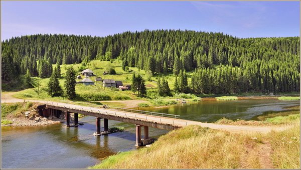
Koiva is one of our most popular rivers. Its main advantages are convenient access, the possibility of access to the river in several places, good parking areas along the banks, and the end of the route in the city of Chusovoy near the railway station.
You can raft on the Koiva all summer long. Rafting is most popular during spring floods (the first ten days of May). In summer, in hot, dry weather, there may not be enough water in the upper area above the village of Biser.
The Koiva in its upper reaches reaches the railway near the Tyoplaya Gora station, then flows for about eight kilometers next to the railway to the east of it, then crosses it between the stops 255 km and Ust-Tiskos and goes southwest. It’s convenient to go to the river:
- in Tyopla Gora to the road bridge (about three kilometers),
- from the stop 255 km by rail to the bridge over Koivu (about two kilometers)
- in Ust-Tiskos (100 meters before the tributary of the Koiva - Tiskos, on the opposite bank it is convenient to collect ships and start rafting, and three kilometers later the Tiskos flows into the Koivu in front of the railway bridge). From the bridge it is about thirty kilometers to the village of Biser.
The village of Biser is located 12 km from the railway station of the same name and is connected to it by bus. The next village on the river is Kusye-Alexandrovsky. It is connected by bus to Pashia station. It is about 35 km along the river, approximately in the middle of this section there is another attraction - Fedotovsky threshold, formed by a large stone extending from the right bank into the water for about 6-8 meters. The end of the stone in the river is doused with water, forming a drain and a shaft about a meter behind it. The threshold is located at the left turn and at the left (inner) bank, the passage is clear.
Another route option is to start rafting along the Kusya River, which can be reached along the road from the Koiva electric train stop (about seven kilometers to the southeast). There is enough water in the river during the spring flood, but the river is narrow, winding and requires sufficient experience, a well-coordinated crew and attention. After 15-20 km there is a pond on the river, from the dam of which it falls into Koivu with a three-meter waterfall. Thrill-seekers can also go through the waterfall (insurance is required).
After 20 km, Koiva flows into Chusovaya. At the mouth on the left bank is the village of Ust-Koiva. There are two camp sites here, where you can stop, relax, and go to the bathhouse. The town of Chusovoy is still about 20 km away. It is more convenient to finish the route on a small spot at the mouth of a small river flowing in from the right next to the station.
In spring, the entire route from Tyopla Gora to Chusovoy can be completed in 3-4 walking days.
Route: Kusye-Alexandrovsky village – Ust-Koiva village
Length of the active part: 42 km.
The cost of individual tours is calculated separately!
We are waiting for your call: tel. 234-22-58
You can come with your own transport, leave the car on the territory of the base and get a discount on the tour of 900 rubles.
Tour program:
18:00
When the tour starts on Sunday, departure to
10:00
!!! (if you used our transfer services Perm-camp site-Perm)
21:00
arrival on the bank of the Koiva River, accommodation in tents
21:30
dinner, meeting the instructors, getting food and equipment. Overnight for 3-4 people in tents.
10:00
rising, washing in the river.
10:15
Breakfast.
11:00
Rafting along the Koiva River to the Shishikha tributary. During the day: optional: excursions to the stones “Maly Shaitan”, “Strelny”, “Arochny” (the objects are located along the banks of the Koiva River).
14:30
Lunch at the “green parking lot”, continuation of the rafting to the “Pochta” parking lot.
20:30
Breaking up the Bivouac. Dinner. Overnight in tents.
9:00
rising, washing in the river.
9:30
Breakfast.
10:00
Rafting along the Koiva River to the confluence of the Koiva and Chusovaya rivers (Former Almazny village)
15:00
Dinner. (when leaving on the first day at 10:00 and if the group fits into the schedule) Excursion to the natural monument of the “Dyrovaty” stone (picturesque rocky outcrops of Carboniferous limestone with a large cave arch 24 m high). + souvenir photos at beautiful viewpoints. (Attention! This excursion may not be possible due to weather conditions)
18:00
Departure by bus to the city of Perm.
23:00
arrival of the bus in the city of Perm.
Route: Tyrym village - Kusye-Alexandrovsky village
Length of the active part: 15 km.
Cost of rafting along the Koiva River (2 days).
| Cost of a standard route for a person in a group: | ||||
| deadlines: | Weekdays | weekend | ||
| 1950 | 2400 | |||
| Transfer | 1000 | 1000 | ||
| Discounts: | ||||
| for children 3-7 years old | 40 % | |||
| for children 8-12 years old | 30 % | |||
| for children 13-16 years old | 10 % | |||
| Included in the price: | 3 meals a day (we prepare it ourselves) rental of tourist equipment instructor accompaniment excursions according to the program transfer Perm – Koiva river – Perm |
|||
You can come to this route by your own car.
Leave it on the territory of our camp site for free.
In prefabricated groups, the route will take place when the group consists of 18 people or more
Tourists are provided with all the equipment necessary for the trip: 6-seater catamarans, oars, life jackets, insulating mats, sleeping bags, 2-, 3-, 4-seater tents.
8:00
Bus departure from our office in Perm (53 Sibirskaya St. (formerly Mirabella)
12:30
Arrival at the “Lost World” tourist center Lunch.
13:30
Transfer to the starting point of the rafting village of Tyrym, meeting the instructors, receiving food and equipment.
14:30
Arrival at the bank of the Koiva River. Completion of safety training.
15:00
Start of rafting on the Koiva River.
19:30
Breaking up the Bivouac. Dinner. Overnight for 3-4 people in tents.
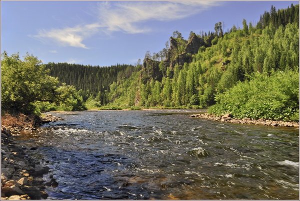
The Koiva River flows in the Middle Urals, in the Perm Territory. An excellent river for tourist rafting, although rafting on it requires some experience, since the river has many difficult obstacles for beginners (rapids, rifts, pressures, trees fallen into the water in combination with a fast current).
The name of the river comes from the Komi-Permyak words “koy” - “spray” and “va” - “water”. Those who named the river so noticed its stormy character. In spring, the current speed in some places reaches 2 meters per second.
Koiva is the right tributary of the Chusovaya River. The length of Koiva from source to mouth is 180 kilometers. The water is clean and clear. The main tributaries of the Koiva are: Tiskos, Kyrma, Biser, Bolshoy Tyrym, Kusya. The Koiva River has a mountainous character. It is fast, winding, and has a lot of rolls.
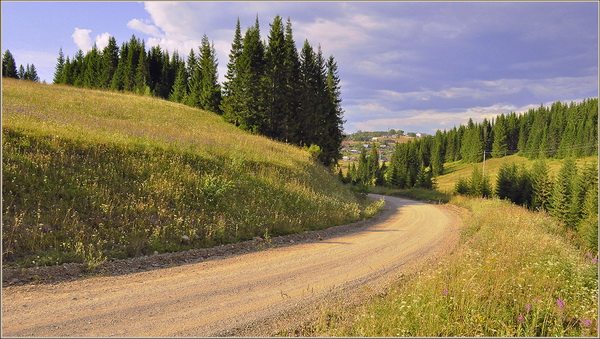
The banks of the river are covered with forest, there are few settlements. The largest settlements on Koiva are Teplaya Gora, Stary Biser and Kusye-Alexandrovsky. They are convenient for throwing and throwing. The oldest and largest of them is Kussier-Alexandrovsky. An ironworks at the confluence of the Kusya and Koiva rivers was founded in 1751.
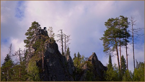
There are beautiful rocks along the banks of the river. They are much more modest than the majestic rocks on the Chusovaya River flowing very nearby. However, Koiva is beautiful in its own way! There are few tourists on Koiva. There are plenty of places for parking and firewood.
It is best to raft along the Koiva in high water - in May or June, or after heavy rainfall. In summer the river becomes shallow. Especially in the upper reaches. In spring, it is suitable for rafting from the Teplaya Gora station and up to the confluence with Chusovaya (it is convenient to sail to the city of Chusovaya on the river of the same name).
In summer it is better to start rafting from Kussier-Aleksandrovsky. However, even here you will often have to navigate the watercraft in the shallows. Here and there on Koiva a dredge took over, leaving behind a dug up riverbed and islands.
There are several options for the rafting route along the Koiva River. Here are the settlements from which you can start the route and end it: Teplaya Gora - Ust-Tiskos - Stary Biser - Kusye-Alexandrovsky - Ust-Koiva - the city of Chusovoy (Chusovaya River).
The total length of the route from Teplaya Gora to the city of Chusovoy is about 180 kilometers. In the spring, with rapid currents, the entire route from Teplaya Gora to Chusovoy can be covered in three to four days.
In the section from the Teplaya Gora station to the Ust-Tiskos station, the Koiva flows for about 8 kilometers near the railway. When traveling by rail (section Chusovskaya - Nizhny Tagil), you can start rafting from either one station (however, the path to the river from Teplaya Gora is much closer).
In Kusya-Aleksandrovsky, the discharge of the Kusya River into the Koivu waterfall is interesting. Some extreme water tourists go through this drainage on catamarans. This is quite dangerous and requires a lot of experience.
After the village of Kusye-Alexandrovsky the river becomes wider, fuller and calmer. Although there are troubled areas here too.
In addition to fast rapids, there are rapids and rifts on Koiva. The Fedotovsky rapids and the Kalistratovskaya shiver are especially good (both attractions are between Stary Beads and Kusye-Aleksandrovsky).
The Fedotovsky threshold does not pose much danger, however, beginners should pass it carefully. The length of the Fedotovsky rapids is about 500 meters.
Previously, near this threshold there was the village of Fedotovka. Now all that remains of it is a clearing, the name of the threshold and the tract on the map.


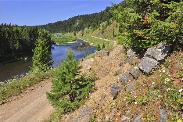


During the trip, you can look into the underground kingdom of caves, see the Royal Gate, visit the site of a primitive man, see the blue lake (... it is unique in the nature of its origin and almost sacred. The water is clean and transparent. The trees, rustling their leaves, bent over the blue surface, hiding this miracle from everyone and keeping the secret hidden in the depths of the waters forever...), enjoy the beauty of the coastal rocks. Immediately below the village of Kusye-Alexandrovsky, beautiful white cliffs covered with fir forest appear on the banks; There are many niches and caves in the steep walls. The places are very picturesque. Coastal cliffs give way to long creeks with trees hanging over the water. The water is very clean, the bottom is visible like in an aquarium. There are many islands and channels. 14 km above the village of Kusye-Alexandrovsky, beautiful white cliffs covered with fir forest appear on the banks; There are many niches and caves in the steep walls. The places are very picturesque. Coastal cliffs give way to long creeks with trees hanging over the water. The water is very clean, the bottom is visible like in an aquarium. There are many islands and channels. Below the village of Ust-Koiva, the Koiva flows into the Chusovaya River. At the turn, the Red and Tash stones rise on the right. At the next turn there is the Shakhov stone, opposite it the Ponysh River flows. On both sides of the mouth rise the cliffs of the Ponysh stone. On the left bank of the Ponysh River (the left tributary of the Chusovaya River) in the limestones of Mount Kladovaya there is the Chudesnitsa cave. Downstream on the right bank of the Chusovaya you can see the Pechka stone. There is a cave in the rock that ends in an underground lake. On the left, Chusovaya receives the Bolshaya Isakovka River, and behind it stands the Plakun stone like a gloomy wall. The constantly flowing water over the stone gave rise to its name. Then Chusovaya goes around Mount Alabaster on the right, and at the exit from the bend there is the Shaitan stone. Its white cliff is beautiful - an obelisk against the backdrop of a dark forest. A kilometer below, on the left bank, the Medvezhka stone rises like three rocks. Behind it the river turns sharply and comes out to the Gladky stone. There is a small roll behind the stone; on the right, pay attention to the Bolshaya Glukhaya River. Its length is about a hundred meters, but the current is very fast. The river flows from a deep (56 meters) small karst lake, called the Blue Lake due to the color of the water - copper sulfate. Beyond the river, the Deaf stones begin. Chusovaya flows in the last stone corridor on its way. The Bolshiye Gluhiye stones rise along the left and right banks. In the stones of Bolshie Glukhikh, on the right bank, there is the largest accessible grotto. Below the Bolshiye stones, the Small Gluhiye stones begin, located on both banks of the Chusovaya. On the left is the last stone, Scallop. Behind the stone, Chusovaya, as it were, pushes apart the narrow banks that are boring to it and, making two gentle turns, takes the boats out into the city of Chusovoy. In the town of Chusovoy, 300 meters from the railway station, the journey ends.


Phuket with children: where to stay and what to do
District "Imeretinskaya Lowland" in the city
TOP Russian lakes with unusual names
The best beaches of the island of Sri Lanka: photos, description Taxi from the airport to the city
The ship "Akademik Shokalsky" makes money on cruises. Tourists keep the fleet afloat